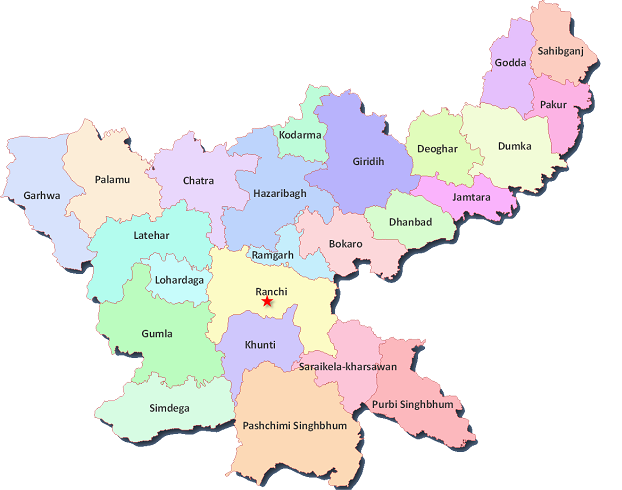
Jharkhand Map
District : Bokaro
Code : BO
Headquarters : Bokaro
Population (2011) : 2,061,918
Area (km²) : 2,861
Density (/km²) : 716
Official website : http://bokaro.nic.in/
District : Chatra
Code : CH
Headquarters : Chatra
Population (2011) : 1,042,304
Area (km²) : 3,700
Density (/km²) : 275
Official website : http://chatra.nic.in/
District : Deoghar
Code : DE
Headquarters : Deoghar
Population (2011) : 1,491,879
Area (km²) : 2,479
Density (/km²) : 602
Official website :
District : Dhanbad
Code : DH
Headquarters : Dhanbad
Population (2011) : 2,682,662
Area (km²) : 2,075
Density (/km²) : 1,284
Official website : http://dhanbad.nic.in/
District : Dumka
Code : DU
Headquarters : Dumka
Population (2011) : 1,321,096
Area (km²) : 4,404
Density (/km²) : 300
Official website : http://dumka.nic.in/
District : East Singhbhum
Code : ES
Headquarters : Jamshedpur
Population (2011) : 2,291,032
Area (km²) : 3,533
Density (/km²) : 648
Official website : http://jamshedpur.nic.in/
District : Garhwa
Code : GA
Headquarters : Garhwa
Population (2011) : 1,322,387
Area (km²) : 4,064
Density (/km²) : 327
Official website : http://garhwa.nic.in/
District : Giridih
Code : GI
Headquarters : Giridih
Population (2011) : 2,445,203
Area (km²) : 4,887
Density (/km²) : 497
Official website : http://giridih.nic.in/
District : Godda
Code : GO
Headquarters : Godda
Population (2011) : 1,311,382
Area (km²) : 2,110
Density (/km²) : 622
Official website : http://godda.nic.in/
District : Gumla
Code : GU
Headquarters : Gumla
Population (2011) : 1,025,656
Area (km²) : 5327
Density (/km²) : 193
Official website : http://gumla.nic.in/
District : Hazaribag
Code : HA
Headquarters : Hazaribag
Population (2011) : 1,734,005
Area (km²) : 4,302
Density (/km²) : 403
Official website : http://hazaribag.nic.in/
District : Jamtara
Code : JA
Headquarters : Jamtara
Population (2011) : 790,207
Area (km²) : 1,802
Density (/km²) : 439
Official website : http://jamtara.nic.in/
District : Khunti
Code : KH
Headquarters : Khunti
Population (2011) : 530,299
Area (km²) : 2,467
Density (/km²) : 215
Official website : http://khunti.nic.in/
District : Koderma
Code : KO
Headquarters : Koderma
Population (2011) : 717,169
Area (km²) : 1,312
Density (/km²) : 427
Official website : http://koderma.nic.in/
District : Latehar
Code : LA
Headquarters : Latehar
Population (2011) : 725,673
Area (km²) : 3,630
Density (/km²) : 200
Official website : http://latehar.nic.in/
District : Lohardaga
Code : LO
Headquarters : Lohardaga
Population (2011) : 461,738
Area (km²) : 1,494
Density (/km²) : 310
Official website : http://lohardaga.nic.in/
District : Pakur
Code : PK
Headquarters : Pakur
Population (2011) : 899,200
Area (km²) : 1,805
Density (/km²) : 498
Official website : http://pakur.nic.in/
District : Palamu
Code : PL
Headquarters : Daltonganj
Population (2011) : 1,936,319
Area (km²) : 5,082
Density (/km²) : 381
Official website : http://palamu.nic.in/
District : Ramgarh
Code : RM
Headquarters : Ramgarh
Population (2011) : 949,159
Area (km²) : 1,212
Density (/km²) : 684
Official website : http://ramgarh.nic.in/
District : Ranchi
Code : RA
Headquarters : Ranchi
Population (2011) : 2,912,022
Area (km²) : 7,974
Density (/km²) : 557
Official website : http://ranchi.nic.in/
District : Sahibganj
Code : SA
Headquarters : Sahebganj
Population (2011) : 1,150,038
Area (km²) : 1,599
Density (/km²) : 719
Official website : http://sahibganj.nic.in/
District : Seraikela Kharsawan
Code : SK
Headquarters : Seraikela
Population (2011) : 1,063,458
Area (km²) : 2,725
Density (/km²) : 390
Official website : http://seraikela.nic.in/
District : Simdega
Code : SI
Headquarters : Simdega
Population (2011) : 599,813
Area (km²) : 3,750
Density (/km²) : 160
Official website : http://simdega.nic.in/
District : West Singhbhum
Code : WS
Headquarters : Chaibasa
Population (2011) : 1,501,619
Area (km²) : 7,186
Density (/km²) : 209
Official website : http://chaibasa.nic.in/
